Besides the navigation equipment used by the navigator, the latter also requires certain instruments, publications and stationery to assist him in the performance of his duties. The items include the following:
Charts. Just as you would require roadmaps to plan and monitor your holiday, so does the navigator when planning a voyage. He would start with a small scale chart, if possible, with both the departure point and the destination displayed. Here he would choose the route he wished to follow. He would then transcribe this route onto larger scale charts which contain more detail. Finally when he approaches his destination, he will choose even greater scaled charts which will allow him to navigate the last few miles with greater accuracy and safety. Although paper charts are being phased out, they are still being retained as a back-up for the automated (digital) system.
There are two types of chart used for nautical navigation. They are the Mercator and Gnomonic projections. For navigation in most areas traversed by commercial and naval vessels use is made of Mercator charts. When sailing in very high latitudes ie in the region of the north and south poles, Gnomonic charts are used. The main difference between the two is that on Mercator charts the meridians are parallel, whilst on Gnomonic charts the meridians converge at the poles. Later on during the course we will be discussing the charts in greater detail.
Sailing Directions. There are sailing directions for every country with the sea as one or more of its borders. Sometimes they are referred to as “Pilots”. The purpose of the sailing directions is to provide the mariner with a very comprehensive description of all the coasts he is likely to navigate. It gives all aspects of a coast, the predominant weather, climate, tides, currents, dangers, ports, the facilities offered, local regulations, etc. They are produced and published by the hydrographic authority for each country. In South Africa’s case the authority vests in the Hydrographer of the South African Navy.
Tide Tables. These tables provide data for the prediction of the height of tide at the various ports covered by the tables. They provide the predicted times and heights of low and high water at every port as well as the phases of the moon for every day of the year. They also provide the predicted hourly height of tide for every day of the year. Towards the back of the tables one will also find the daily times of sunrise, sunset, moonrise and moonset at every major port in South Africa and Namibia.
Nautical Almanac. The nautical almanac provides data used for astro-navigation. The data is used in conjunction with measurements taken of celestial bodies (ie sun, moon and stars) with the use of an instrument called a sextant.
Nories Tables. These tables are used for voyage planning. The data provided will enable the navigator to work out his courses and distances to be covered during a voyage. It also provides data which is used to determine azimuths of heavenly bodies in astro-navigation
List of Lights and Radio Signals. These lists give the location and characteristics of all lighthouses situated on the coast as well as the location of all maritime radio stations, the times they operate, the services they offer and technical details of their transmissions.
Notices to Mariners. These are notices published by the local hydrographic office providing data on the publication of new charts and navigation publications, corrections to charts and publications. It also provides navigational warnings for all sea going vessels.
Chart Symbols and abbreviations. This publication gives an in-depth description of all the symbols and abbreviations one is likely to encounter on nautical charts. The symbols are international and apply to all charts produced for navigational purposes.
Chronometers. A chronometer is a very accurate watch used for astro-navigation where precise times are required. They are checked at least twice a day by comparing them to a special radio signal which is continuously transmitted by the UK’s observatory at Greenwich. Any discrepancy is noted in a special logbook which keeps track of chronometer errors.
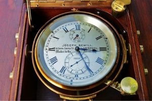
Ship’s chronometer
Azimuth ring. This is a metal ring that fits on the top of a compass or compass repeater. It is capable of being rotated through 360° and has a prism at one end and a V sight at the other. This is used to take bearings.
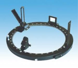
Azimuth ring
Azimuth mirror. At the rear of the sighting prism on the azimuth ring there is a rectangular mirror consisting of reflecting black glass. The mirror is hinged at one end and can be bent upwards. It is used when taking bearings of the sun at high altitudes. The sun is reflected in the mirror and being black it cuts out the fierce glare of the sun.
Parallel rulers. This is a ruler specially constructed for laying off bearings and courses on a chart. They are either constructed of a combination of plastic and metal or just metal.
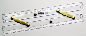
Parallel ruler
Dividers. Dividers are used to measure distance on a chart.
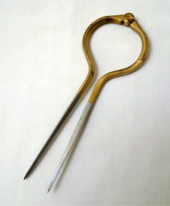
One handed dividers
Soft lead pencils. Soft lead pencils are used for laying off courses and bearings on a chart. Since a chart has to be used over and over again, the pencil markings/lines need to be erased from time to time. Any thing harder than a 2B pencil will be difficult to erase and therefore it is essential that 2B pencils are used for chartwork.
Compass. Another instrument that is essential is a mathematical compass, i.e. the instrument used for drawing arcs on a chart.

Compass
Protractor. A plastic protractor is also necessary for determining angles on a chart.
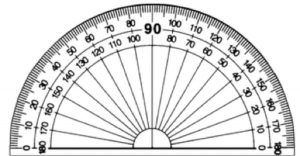
Protractor