Clouds are formed when warm, moist air rises until it reaches the air’s saturation point (dew point). After this the moisture in the air condenses into visible droplets and clouds are formed. There are two basic types of cloud.
Cumulus clouds.
When air is heated by the surface of the earth or water, it expands, becomes lighter and rises. As the air rises, it expands further because of the drop in atmospheric pressure and cools because of the expansion. If the cooling continues beyond the point at which the air is saturated, clouds result. Clouds formed in this way are classified as cumulus or cumuliform clouds. They can be identified by their flat horizontal bases and rounded cauliflower heads which spread out at great heights into the shape of an anvil.
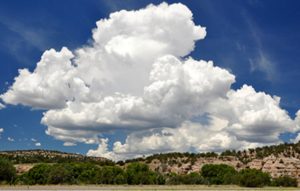
Cumulus cloud.
Stratus or stratiform clouds.
When two air masses of air from different sources and having different characteristics meet, boundary lines are formed where the colder , heavier air runs under the warmer, lighter air and causes it to rise. The latter also expands and cools as it rises and results in the formulation of cloud. This type spreads as a more or less continuous layer and is classified as strati-form or stratus type cloud. Air may also be forced up the sides of mountains and high ground towards which the wind is blowing. The expansion and cooling which results also leads to the formation of stratus type cloud, if air is cooled below its saturation point.
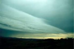
Stratus cloud.
These cloud types can be further classified as follows:
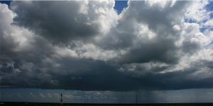
Rain clouds (Nimbus). These are the rain clouds and are darker grey than the others. They can be classified as cumulonimbus or nimbostratus.

Nimbus.
High clouds (Cirrus). These are very high clouds, ie between 6 and 12 kilometers. They are usually fleecy and transparent. They could be classified as cirrus, cirrocumulus or cirrostratus. Sometimes they are formed into curved whisps which are referred to as mare’s (horse’s) tails.

Cirrus with “mares’ tails”.
Medium clouds (Alto). These are medium level clouds, ie between 2 and 6 kilometers. They could be classified as altocumulus and altostratus.

Medium clouds.
Low clouds. These clouds are lower than 2400 metres. They could be classified as stratus, nimbostratus or stratocumulus.
Low cloud.
Low cloud with marked vertical extent. These clouds have a base at between 300 and 2 000 metres and their tops are anything up till 12 000 metres. These clouds are usually cumulus or cumulonimbus.