[vc_row][vc_column][vc_video link=”https://vimeo.com/473802576″][vc_video link=”https://vimeo.com/473802240″][vc_video link=”https://vimeo.com/473801817″][vc_column_text]Major weather systems (Depressions, Tropical Cyclones) have an effect on shipping because strong winds are part of those systems. Those strong winds cause heavy seas that have potential to damage ships and disrupt shipping operations.
Depressions
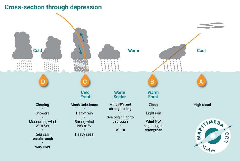
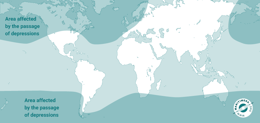
These are weather systems that move from west to east across the Southern Ocean, South Atlantic Ocean, southern Indian Ocean and southern Pacific Ocean. The also develop across the North Atlantic Ocean and northern Pacific Ocean. They form around a low pressure cell and have two major sections
- the warm front that introduces relatively warm air, and sometimes light rain.
- the cold front that introduces colder air (sometimes very cold air as the direction of air movement behind the cold front is from the polar region). The cold front usually brings strong winds (often in very strong gusts), heavy seas and heavy rain.
In southern Africa, depressions affect mainly the south-western areas (from about Cape Columbine to Mossel Bay, although on occasions, the Eastern Cape coast can also experience strong wind and heavy seas during the passage of a depression and its associated cold front.

Tropical Cyclones
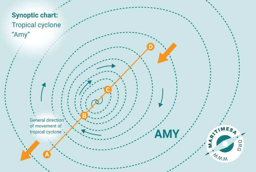
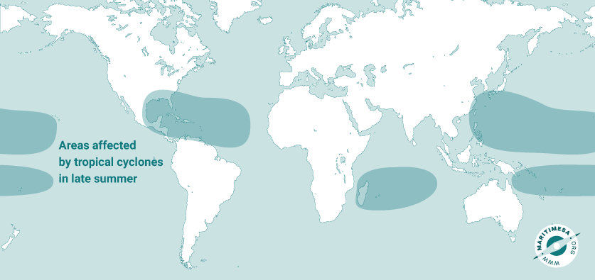
Known as a hurricane in USA and a typhoon in Asia, a tropical cyclone forms around an intense low pressure area in ocean areas near the Equator, and air begins to move around the centre – clockwise in the southern hemisphere; anti-clockwise in the northern hemisphere.. The low pressure cell begins to move south-westwards in the southern hemisphere and north-westwards in the northern hemisphere. Wind strengths can get to around 120 knots, extremely heavy seas occur and extremely heavy rain falls as the cyclone passes. In the centre is the “eye”, an area of calm. Ships avoid these storms as the heavy seas can cause severe damage to them or to deck cargo. Cargo in the holds can shift as the swell increases. Ships will be routed around a tropical cyclone.
Tropical cyclones form in the Indian Ocean and move south-westwards and often affect Mauritius, Reunion, Madagascar and occasionally come ashore in Mozambique. Only one has hit the South African coast in the last 40 years – tropical cyclone Demoina hit the coast near Richards Bay in 1989, causing widespread, serious damage from Mozambique to the south coast of KwaZulu-Natal. Extraordinarily strong winds and widespread flooding occurred – bridges, roads and buildings were badly damaged. Fortunately, ships had either entered port, or had taken shelter, or had steamed away from the advancing cyclone.
Once the cyclone has moved over land, it loses strength and dissipates. Madagascar shields the south-eastern coast of Africa from the worst effects of tropical cyclones. Even though South Africa has had only one cyclone come ashore in the last 40 years, the effects of a cyclone (heavy seas) are felt along the KwaZulu-Natal coast if one should pass into the Mozambique Channel or dissipate before reaching the coast.
Tropical cyclones are given names, the first letter of which indicates the number of that cyclone in the season, e.g. the first cyclone of the season wil leb given a name beginning with the letter A – Amy, or Andrew etc; the second of the season will start with the letter B – Byron or Barbara, the third of the season will start with the letter C – Caroline or Charlie.

Monsoons
- Since early Arabian, Indian and Portuguese seafarers traded between the coast of the Arabian Gulf, India and east Africa, the Monsoon seasons in India have affected trade routes. This was because of changes in season wind directions that of course had an effect on sailing vessels like the Arab dhows and the Portuguese caravel’s. Even modern ships are affected by these wind systems. (See below.)
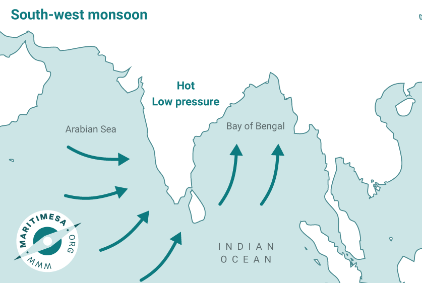
- South-west Monsoon – In the northern hemisphere’s summer (May to September) high temperatures over India cause a low pressure system to form. That low pressure system draws air toward India, and air moving anti-clockwise around that low pressure system is observed as a south-west wind across the Indian Ocean. (See the diagram below.) These winds are constant in strength and can build up a significant swell. This means that ships moving from East African ports to ports along the Arabian Gulf or the Indian west coast will experience a stern sea; those moving in the opposite direction will experience a head sea.
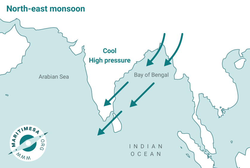
- North-east Monsoon – In the northern hemisphere’s winter (November to March) lower temperatures over India cause a high pressure system to form. That high pressure system causes air to move clockwise around it, and in the process, it flows across the Indian Ocean from the north-east. (See the diagram below.) These winds are constant in strength and can build up a significant swell. This means that ships moving from ports along the Arabian Gulf or the Indian west coast to East African ports to will experience a stern sea; those moving in the opposite direction will experience a head sea.
- Ships crossing the Arabian Gulf or the north-western part of the Indian Ocean will also be affected. If the monsoon has created a heavy swell, ships on those courses may experience heavy rolling.
South-East Gales
Southerly and south-east gales often disrupt shipping operations in Cape Town, Port Elizabeth and Ngqura, especially in summer. Ships, particularly those that are high-sided (e.g. large ships in ballast, containerships, passenger ships and vehicle carriers) are often not able to berth in or sail from ports because of strong winds. Container operations – and sometimes even other cargo operations – often have to stop because of strong winds. Ships’ moorings can part (break) during these times of strong winds.
In summer, the South Atlantic high pressure system usually is located to the west or even to the south-west of the Cape. Air moves anti-clockwise around this system. The strong south-east or southerly winds that blow across the south-western part of the country are caused by that high pressure system “ridging” to the south of the country. (“Ridging” means that the high pressure system elongates to the south of the country.) As the air moves around that high pressure system, it speeds up as it comes around the eastern end of the ridge, creating strong winds across the south-western Cape. As this ridge can remain in place for several days, the strong winds can continue for days, delaying ships and disrupting cargowork.
(See the diagram below.)


Test Yourself
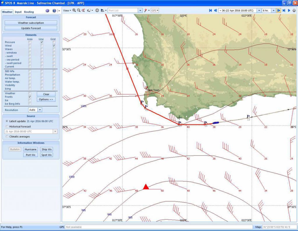
- Below is the weather map showing conditions during a storm which the bulker Atlantic Trader encountered while on a voyage form Durban to Walvis Bay.
- The straight line indicates the course of the ship.
- Each ìfeatherî on the wind symbols represents 10 knots wind speed, e.g.
- Two feathers = 20 knots wind speed;
- Two and a half feathers = 25 knots wind speed.
- A diamond shape on the feather = 50 knots wind speed
- The average swell height off Cape Agulhas is 9 metres from the west.
- Answer the following questions
1.1 Look at the wind speeds and direction. In what season was the voyage from Durban to Walvis Bay undertaken?
1.2 What was the wind speed off Cape Agulhas at the time of the incident?
1.3 Explain the link between the wind speed and that fact that the ship was experiencing heavy seas.
1.4 What weather system was affecting the weather at the time when the ship was off Cape Agulhas?
- The Agulhas Current flows along the east coast towards Cape Agulhas.
2.1 Will the current assist the ship on her voyage between Durban and her position off Cape Agulhas?
2.2 Explain your answer to Question 2.1.
2.3 Atlantic Trader is fully laden. Will she have a low or a high freeboard?
2.4 When steaming from Durban to Cape Agulhas, will she have a head sea or a stern sea?
2.5 Explain your answer to Question 2.4.
2.6 Look at your answers to the questions above.
2.6.1 Write a note of about 50 words in which you describe the conditions off Cape Agulhas as if you were aboard the ship
2.6.2 List three dangers that might concern the shipís Master.
2.6.3 When she reaches a position to the south-west of Cape Point, the ship will turn.
2.6.3.1 Will the wind be a head wind, on her beam, or a stern wind?
2.6.3.2 Will she have the swell running from ahead, on her beam or from astern?
2.6.3.3 Will she roll or pitch as she steams from Cape Point to a position west of Cape Town?
[/vc_column_text][/vc_column][/vc_row]

